Tsum & Manaslu Valley Trek 5213m 24 Days

US $  2630 per person
Trip Code : AHC/MR-01
Price : US$2630
Destination : Nepal
Duration : 24 Days
Grading : Hard
Max Altitude : 5213m
Starts at : Kathmandu
End at : Kathmandu
Trip Route : Kathmandu - Manaslu - Annapurna and Kathmandu
Best Season : March to May/Sept to November

Overview

Tsum Valley: The Tsum Valley is one of the remotest Himalayan secret and secluded Himalayan valleys with emergence of Buddhist faith and its practices. The Tsum valley lies along the border with Tibet, just south of the Tibet's Shisha Pangma(8,046m/26,400ft). It was restricted area till 2008, and then opened for trekkers. The Tsum Valley trek leads you into the majestic surroundings of the Ganesh (Yangra) Himal, Sringi Himal and Boudha Himal ranges. The region once being part of Tibet looks completely different from what you will find elsewhere. The word is derived from Tsumbas to Tsum, Tsumbas people belong to Tibetan origin with their own ancient of dialect, art culture and religion. This valley lies on the northern part of Manaslu; less exposed comparatively to other touristic area. The Tsum people have own way of life that may be surprising to the whole world. The brothers in the family are married to a single girl, which is a practice of polyandry.  This valley used to be an important trade link with Tibet in the ancient time. This area is relatively virgin land for trekkers.
  
The trek begins and ends at Arughat and will take 7 hours drive from Kathmandu. The trail ascends the Budhi Gandaki valley through a mix of dense forest, terraced fields and mountain villages which is dominated by Gurung indigenous peoples. This trail leads both route such as Tsum Valley trek and Manaslu circuit trek. After trekking certainly we will get a feeling of entering truly into the hidden valley. During the trek days we pass through the alpine forests, glacial rivers and enjoy the warm hospitality of ethnic people, via lower Budi Gandaki of Liding, Machhakhola, Jagat and Philim. We visit the ancient Gombas of this region such as Rachen Gompa, Mugumpa and Gomba Lungdang.    

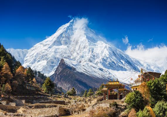
Manaslu circuit trek: The round Manaslu trek will reward the adventures with tremendous alpine Himalayan world. It is one of the challenging treks of Nepal that has been open in 1992 for all the trekkers for international wide. This location gives massive Himalayan views, Gurung culture, Tibetan culture and their hospitality, geological variations which satisfy splendor and natural beauties. Trekking around Mt. Manaslu offers a unique opportunity to experience a reasonably untouched region of Nepal and marvelous beauty along the border of Nepal and China. Manaslu circuit trek is one of the excellent trek with remarkable ethnic culture along scenic Himalayan range, while closest view of Mt. Manaslu(Kang Pungen)(8163m), Himal Chuli(7750m), Mt. Ganesh Himal(Yangra)(7422m) I, Naike Peak, Peak 29 (Nadi Chuli 7871m), Himlung(7126m), Ratna Chuli Lamjing Himal Annapurna II and Gorkah Himal are the breathtaking picturesque of this trek. It contains more than 10 peaks over 6500 meters with activities of faunas such as blue sheep, Marmot, rabbit, Musk deer, Yak, golden Jackal baking deer, Langura, red monkey, Himalayan Pheasants, eagle, vulture and snow cock . There are several flora are existing on this area. The Manaslu trekking gives a high quality and numerous habitats for precious kind of flora and fauna, plant life of all ecological zones, tropical, Sub-tropical, temperate, alpine and sub-alpine are discovered abundantly around the area.    
  
The Mt. Manaslu trek begins from Gorkha district of Budhi Gandaki valley river. We have to cross the snowbound Larkya La Pass (5213m/17,103ft). After descent it takes us through alpine tropical areas, bursting with ferns, bamboo, Pine timber, waterfalls and blue lake. We pass via Sotikhola, Machhikhola, Sirdibas, Khorla, Tatopani, Jagat, Yaruphant, Philim, Namrung, Bhi Phedi, Lho, Shyala, Samagaun, Samdo Dharmasala, Bhimtang Tilje and descend to Marsyangdi valley to the Dharapani on the way to the famous Annapurna circuit trek. From the Dharapani, Manaslu trek toward the Besisahar to Kathmandu. Manaslu circuit trek can be amply rewarded with the enthralling environment and fascinating cultures and traditions of the primitive stage of the Manaslu region. The type of the trek, from the Hindu, Animism, Shamanism center hills to the Tibetan high country dwellers and the superb mountain scenery of the Manaslu Himal and surrounding peaks integrate to make Manaslu trekking circuit taken into consideration one in all a fascinating trekking. 

Trip Highlights

  • View of Gorkha Himal, Himal Chuli, Peak 29, Naike Peak, Ganesh Himal, Himlung, Ratna chuli, Annapurna II and Lamjung Himal.
  • Stunning view Mt. Manaslu 8th highest peak in the world known Killer Mountain.
  • Trek to the base of Killer Mountain.
  • Part of the Great Himalayan trail.
  • The trek off the beaten-Path.
  • To achievement of scenic trail of the trek.
  • New experience of emote and virgin trail with less crowded trek route.
  • To explore the typical Tibetan and Gurung ethnic culture and their life style.
  • Live view of Blue Sheep and Marmot along rest of the flora & fauna.
  • 360 vista of Mountain views
  • Gumba Lungdang is important nunnery where trekkers are welcomed at the evening Puja.
  • Mu Gompa and Rachen Gompa to the south have nuns of the Ngakpa sect.
  • Milarepa's cave and foot print of his
  • The village of Chhokang Paro with stone houses and slate roofs.

Itinerary

Day 1 : Arrival in Kathmandu (1334m/4376ft)


Your arrival is at one of the Himalayan kingdom and small country with natural beauty in Nepal's Trivuban international airport (TIA). Our company representative will pick you up with warm welcome to you at airport with Nepalese custom way. Then, you will be transferred to you at Hotel.

Day 2 : KTM to Sotikhola 700m/ 2296ft (8hr driving)


After our breakfast we drive by Jeep via Trishuli River out of Kathmandu valley towards Budhi Gandaki River on the river bank with passing several Villages through terraces field and jungle. We will stop for lunch on the way. Our driving will be approximately 8 hrs. [Over night at Soti Khola]

Day 3 : Soti Khola to Machhi Khola (869m/2851ft) 5-6hrs


The trail is easy for today; we just follow the left of the Budhi Gandaki River with beautiful narrow valley. Some of the half way is constructing bumpy road. The half of the day will have narrow trail over the rock part of the narrow valley. This area belongs to Gurung ethnic group that are mainly dominated in this area. A few glimpse of Siringe Himal, Ganesh Himal range could be seen. We just follow for small village of Gurung peoples. We could enjoy the beautiful scene of water fall on the right and next one on the right during our trek. [Overnight at Machhikhola]

Day 4 : Machhi Khola to Jagat (1340m/4296ft) 5-6hrs


Machhi khola means fish river where people used to do fishing on this spot in the past so it is famous by fish river on the Budhi Gandaki river bank. After 2 hrs from Machhi Khola, we will reach at the Tatopani where simple hot spring is there. People take shower there on hot spring. After 5-10 minutes, we cross the Budhi Gandaki River to the right where there is landslide area. After we pass through it, the place called Dovan is reached. We will cross the steep part rock trail. Suddenly, we will rich the place Yaruphant. It is small wide sand place. It is temporary for tea house on the season. We make cross Steel suspension bridge which is recently made by Swiss Government after damaged by earthquake. we just cross it to the left of Budhi Gandaki, then, we will arrive at Jagat. [Overnight at Jagat]

Day 5 : Jagat to Lokpa (Start Tsum Valley) (2240m/7349ft)5-6 hrs


Jagat is the main door way of Manaslu Conservation area, which is called upper Manaslu. There are two types of people living in this area which are Bhote and Gurung, Mostly peoples are influenced by Buddhism religion around this area. We could see the beautiful Mountain called Shringi Himal toward the north of this place. From Jagat, we will follow the gentle straight trail some of the part are cliff. We will be at Sirdibas. This village is the old village of Gurung peoples. After 30 minute we cross the river towards the right and rich at the Philim. There is big village with local administration of government officials. This is center hub of Mountain village. We will see the Beautiful valley. Then we will gently climb Chisopani (Eklebhatti) through up to the Lokpa, which is cold place among big jungle around it. [Overnight at Lokpa]

Day 6 : Lokpa to Chumling (2336m/7664ft)(4-5hrs)


Lokpa is the beautiful small place surmounted by big jungle. This is main entrance point for Tsum valley. It is situated between Budhi Gandaki in the left and Siyar Khola in the right. Shirngi Himal & Tewa Himal is standing as mountain hero will be smiling toward us. This is one of the getaways of special area called Tsum Valley. If we are lucky, we could see some of the Faunas like Nepal gray Langur (Semnopithecus schistaceus), Barking deer (Muntiacus muntiak), and wild pheasants are found in this area. We follow jungle trail and cross two bridges for 45 minutes and steel fixed bridge about 45 meters which is supported by Swiss Gov. From here we follow Siyer Khola towards north east of valley. The trail is narrow because of landslide, we just climb steep cliff through Himalayan mixed forest of Pine, Rhododendron. By passing some of the ridge, we gently descend down to Siyer khola and pass narrow suspension bridge. We climb zigzag trail until Chumling Village. Our Lunch and Camp will be in Chumling. [Overnight at Chumling]

Day 7 : Chumling to Lamagaun (3302m/10833ft)(5-7hrs)


Chumling is a small and old village of Bhote(Means Tibet peoples) peoples. You will see mostly Tibetan dominated land around here. There is a school. The villagers are sending the kids at the school. Around the village you could observe stone carving Mane wall. Mostly the buildings are built with stone walls and wooden roofed in this area. We could see view of Shringi Himal and some glimpse of Ganesh II and Ganesh Center. People farms Buckwheat, potato, Uwa. Some people survive with pastoral for their livelihood at this region. The trail leads us slope and high rugged mountain with gentle straight from Chumling to until Domje which will take 2hrs approximately. There is a Tibetan medical treatment place at the Monastery which is called Amji. This center is collapsed by earthquake. So now you may not find it. We cross one small river. You need safety because of falling rocks by big wind and Ghoral over the mountain until Chhekamparo. Chhkangparo has 40 houses. You could see traditional old type of house around it. It is a beautiful valley with open wide valley. Like to the east some glimpse of Ganesh, Churke Himal and Kipu Himal to the east, Chamari Pema Himal towards west north Siringi Himal , Rani peak, Bauddha Himal and Gorkha Himal in the west side of Mountain. After Chhokangparo trail it is easy that leads at Lamagaon. It will take 1:45 hrs to reach at Lamagaon. [Overnight at Lamagaon]

Day 8 : Rest Day valley Excursion Lamagaun.


Lamagaon is wide valley and open flat area near Siyar Khola bank. It lies between Pama Himal to the northwest and Ganesh Himalaya, Churke, Kipu Himalaya to the south east. Tibetan people are live in normal houses which are about 10-15 houses are in this area. There are wide and nice farmlands where people farm wheat, uwa, buckwheat and potatoes. The main occupation of these villagers is raring keeping cows, yaks and sheep. There is one famous Gompa which is called Milarempa Cave (Flying Pigeon Cave) which is one of the most sacred caves in the Tsum valley. It is situated at foot hill of the rugged cliff near Burji Village. Milarepa, the famous Tibetan saint meditated in this cave. There are 3 separate gumbas attached to this rocky cave. There is statue of Milarepa, and his footprint on the rock, Avalokiteshwara, Buddha and Tara etc. There is another Gompa which is called Chi Phu which is for mediation. If you cross a river, there is a famous among Monastery school of Nunnery. It is the branch of Kapan Monastery of Kathmandu which is called Rachen Gompa. If you are interested to visit, it will take 15 minutes from Lamagaun. This valley is lying between Chhyossing Himal in the left west side and Churke Himal & Kipu Himal. From Lamagaon we walk easily to Phurbe Village, Pangdun Village, Chhule & Nile Village which is last village of Tsum Valley.[Overnight at Lamagaun]

Day 9 : Lamagaun to Mugumba (Best view point) (3700m/12,139ft)(4 hrs)


Mu Gompa is peaceful with full of open blue sky; and is situated at 3700m/12,139ft from sea level with single monastery at the lap of sloppy mountain. There is less vegetation' some family of Juniper plants and Himalayan shrubs cover the open lands. There is no human habitation except monastery. Of course some of the Yak's group will grazing around the mountain side. You could see that yak huts are found open space. It is more possible to see some groups of Blue Sheep, Golden Jackal (Canis Aureus) & Empheyon Pheasant at the slope of Mountain. You can see the way of Tibet border.
 
 
If you have extra day for hike from Mu Gompa to Thapla to the left destination of Tibet border and Nayula Bhanjyang through junction point of Kalung meadow you may have it. There is another Nunnery Monastery on the left of Mu Gumpa which takes 30 minutes from here. This Monastery is related to Gumbalungden. According to the local peoples of in this valley, Tsum means hidden in Tibet language. So this area was hidden from long time from human beings. In this way Tsum(hidden) Valley has been newly discovered. [Overnight at Mu Gumpa]

Day 10 : Mu Gompa to Chhokang Paro(3031m/9944ft) 6hrs


After exploring wonderful hidden valley, we follow the right of river side until Lamagaun. The way is floating gentle slope down till Chhekamparo with Picturesque view of 360 vistas of Hilamayan, such as south east Ganesh I, Ganesh II, Ganesh VI, Ganesh (Pabil) IV, Churke Himal and Kipu Himal to the east, Chamari Pema Himal toward north Siringi Himal , Rani peak, Himalchuli north Bauddha Himal in the west side of Mountain. [Overnight at Chhokangparo].

Day 11 : Chhokang Paro to Gumba lungdang (3200m/10,498ft)(Stay at Gumba 2 night for Ganesh Himal) 8 hrs


Morning breakfast gives us good energy to decent down to Domje, and we cross the simple bridge and begin ascending about 800m until Gumbalungden. We follow a slope hill through pine, Juniper & birch jungle to reach at the point. There is only one old Nunnery Monastery there with beautiful views of Ganesh Himal and Shrigi Himal. It is the only monastery there, like Mu Gompa. [Overnight at Gumba Lungdang]

Day 12 : Gumba lungdang to Lokpa (2240 m/7349ft)(8hr)


Having beautiful views and experiences we descent down about 800 meters till Domje, After Domje we gentle pass through jungle trail at Ripchet village. This village is located on the small hill with 35 houses where a lot of damage occurred by earthquake in 2015. We will stop for our lovely lunch at here with some glimpse of Ganesh Himal and Shringe Himal. After Ripchet we descend down to river through small jungle and reach at Lokpa. [Overnight at Lokpa]

Day 13 : Lokpa to Bihi Phedi (1990m/6,528ft) 6 hrs


We decent down toward Sher Khola and cross over the Buddhi Gandaki River. We follow left to Buddhigandaki River until Deng. We walk through mix forest including Himalayan bamboo. Trail will be narrow around this area. After Deng we cross towards bridge on the left side. We just follow narrow valley through passing cliff trail. Finally we will arrive at Bhi Phedi. [Overnight at Bihi Phedi]

Day 14 : Bihi Phedi to Namrung (2630m/8,628ft)(6hr)


BhiPhedi is small and old village of Tibetan settlement. There are two Villages Phedi And Bhi which are separate villages. You could see some old Buddist Tsorten along the trail at Bhi village. You could see some Himalayas View of Shringi and Ganesh. The trail goes normal and gentle until Ghap. We climb gentle up through the jungle trail and we will reach at Namrung. [Overnight at Namrung]

Day 15 : Namrung to Lho (3180m/10433ft) 5-6hrs


Namrung is located above small north face slope land. It is surmounted by jungle and narrow valley. You could see Ganesh Himal and Shirigi Himal towards south direction from here. The trail leads us north direction of narrow valley along Budigandaki River at the the place call Lihi Lamagaon - the view point of Himalchuli. After crossing Hinang Khola, we ascend past through the Sho village where there are some possibility to see a new monastery which was made by local people. On the way to the Sho village you can see Manaslu and Nike Peak towards Northwest. Then reach at Lho. Lho is one of the best places for trekkers to explore of Ribung Gompa with Kandjur Scripts Monastery along the beautiful view of Mt. Manslu enjoying beautiful Mountain View an interesting cultures and their custom, which may feel you a different world with its beauty. [Overnight at Lho Village].

Day 16 : Lho to Samagaun(Ryo) (3520m/11,548ft) 4:30hrs


Lho is small settlement of Tibetan and viewable of Mt. Manaslu and Monastery. There is one Kandjur Scripts Monastery. We will explore monastery and its importance. Lho is peaceful land and nice village. The trail begins gentle up through Pine forest crossing small khola till Shyala. Shyala is one of the best places to see stunning 360 view of whole mountains such as Shringi Himal, Kutang Himal, Samdo(Sonam) Himal Gorkha Himal, Himal Chuli 7893m, Nadi Chuli(Peak 29) 7871m, Mt. Manaslu(Kang Pungen) 8163m and Naike Peak 6211m. After having best views, we ascend through Pine forest then cross the bridge. Then, we attempt flat land of Samagaon(Ryo) a village full of Tibetan with own building architecture, with view of Manaslu, Larke and Naike Peak. [Overnight at Samagaun]

Day 17 : Rest day Samagaun.


Samagaun is the Biggest Village and center hub for Himalayan settlement of Tibetan peoples. It is located under the lap of Mt. Manaslu surrounded by many more Himalayas that looks like city of Heaven about 45 houses. This is the local administration part of these areas. There is a vibrant Buddhist monastery Pema Chholing Lkhakhang, and a police check post. Today is rest day. There are two options to utilize our time. One is to explore Monastery which will take 20 minutes from your hotel, about one hour hike Birendra Tal (Lake). This lake is named after let king Birendra Birabikram Shah (He was killed on Royal massacre in 2001 in Narayanhity Palace at Kathmandu) and village tour around Samagaun. The Second option is to hike to Manaslu base camp, which takes 8-9 hrs that depends on your physical fitness too. These activities helps to you acclimatize for coming Larkya pass. [Overnight at Samagaun]

Day 18 : Samagaun to Samdo (3875m/12,713ft) 3-4hrs


The trail is easy for today as we follow narrow valley towards Samdo. There is not a jungle anymore. It looks open pastureland of valley. There is some possibility of wild animals Jharal, blue sheep and grazing yaks and horses around the areas. We walk observing such a beautiful valley and animal activities with capturing on our camera finally. We will get to the Samdo. Samdo is a beautiful small narrow village it is located on the lap of Samdo Himal, Pangboche Peak, and Naike Peak. This is the last village of this area where the Himalayan people are permanently habited. It is also the path to the Tibet during the 15 to 16 century. People of this area were dependent on food supply for Tibet. They still go for selling yaks, sheep and getting some food supplements from Tibet. It takes about 2 days to get in to the Tibet local market. These people survive by animal husbandry such as yaks, sheep and farming of buckwheat, potatoes, wheat and some seasonable vegetables. For the rest of the day we see Blue sheep and Marmot with hike and own camera. [Overnight at Samdo]

Day 19 : Samdo to Dharmasala (4460m/14,632ft) 4-5hrs


After delicious breakfast in the morning, our trek begins towards the west of the Samdo. You do not find any villages on the trail, except Blue Sheep, Marmot and grazing Yaks around beautiful Himalaya. We cross a short bridge over the main source of Budhi Gandaki river and ascend up to the slope mountain with a different types of rhododendron (Sunpati) bush. We will suffer due to lack of oxygen. That's why our step will be slow. Beside that you may enjoy with wild animals activities on the trail finally we get to the Dharmasala. [Overnight at Dharmasala]

Day 20 : Dharmasala to Pass Larkya La (5213m/17,103ft) to Bhimtang(3590m/11,778ft) 8-9hrs


Dharmasala is the located on the lap of Fukang Danda, which is on the base of Mourein of Himalayan base. You could see Nike Peak, Larkye Peak, Pandanda toward southern, and Tibet border Mayo Himal. We will have a hard day so, we wake up early morning for our preparation to cross the Larkya la Pass. We will have our breakfast and pack our lunch. The trail is steep in the starting for about 45 minutes, and we walk on the big moraine route along the trail. It will take 4hrs to be at the top of Larkya la. We could see Larkey Peak, Nike Peak on the left, Khankuru, Himlung and far Ratna Chuli in the west, Annapurna II in the North West, Gyajikang, Lamjung Himal, Ponkar Lake and Nyamlo Lake are viewable from the pass. After great view of these mountains, we descend down very steep moraine route about one hour and then we descend until Bhimtang via below Ponkar Lake. Finally we get to the Bhimtang [Overnight at Bhimtang]

Day 21 : Bhimtang to Tilje


Bhimtang is beautiful place for trekker, which is surrounded by beautiful mountain at the lap of Dangboche Kharka. It was the place for main trade market during the ancient period between Tibet and Bhimtang which were barter and used to deal on this place of local product such as yaks, meat, milk, potatoes, key luck, salt and also Pasture land for Tilje's Gurung peoples. We could see Manaslu Himal on the east side with different angle of view from here and Himlung Himal toward north from Bhimtang. The trail is narrow with bamboos bushes, pine, oak and birch of mixed forest on the half way down. We may see beautiful views of Mt. Manaslu, Manaslu north and Himal Chuli. We trek via Hampuk, Yak Kharka, Kharche, cross a Soti khola and Goa (Gho) village and reach at Tilje. Gho Village is big village with Gurung habited area of the trail after Tilje. [Overnight at Tilje]


Day 22 : Tilje to Dharapani


Tilje is located on the bottom of high mountain between Single Himal and Krampu Danda with narrow valley on the rim of Dudh Khola with habitant's of Gurung indigenous. We walk about 2hrs to get to the Dharapani which is famous for Annapurna circuit trek junction from this place. [Overnight at Dharapani]

Day 23 : Dharapani Drive to Kathmandu(1334m/4376ft)


After morning breakfast, we drive to Kathmandu or Pokhara as your program. There are three options for you. Option no 1: we drive via Besi Sahar to Kathmandu by jeep for 12 hours. Option No 2: We drive to Pokhara for 8:30 hours. Option No 3: start famous Annapurna circuit trek for another 12 to 13 days trek for further adventure.

Day 24 : Departure to Your Home.


We head to airport approximately 3 hours before your scheduled flight. Our journey and services in Nepal ends from today for this trip, Visit Nepal Treks and Expedition Pvt.Ltd representative will drop you to Airport for your best memorable of glance of Himalayan. Meanwhile, if you have some negative experiences that knowingly and unknowingly, we request to you remove it from your mind before leaving Nepal and carry beautiful memories with hope of your good life and prosperity with hope that you have plenty of time to plan your next adventure in the wonderful country of Nepal.

What's included

  • Airport pickup and drop.
  • Welcome and Welfare dinner.
  • All ground transportation by Tourist Bus/Private Vehicles.
  • Hotel in Kathmandu (3 star category) on a twin sharing bed and breakfast basis.
  • All accommodations with suitable guest house during treks.
  • Meals Breakfast, Lunch and Dinner During trek.
  • Down Jacket, Seasonal Sleeping Bag (returnable after Trek completion).
  • An Experience Government license holder, English speaking Trekking guide (First Aid and Eco trained) and Sherpa Assistant.
  • All necessary Paper works and Manaslu, Tsum Valley and Annapurna permits.
  • Travel and Rescue arrangements.
  • Exclusive Medical Kit Bag.
  • Trekking Porter(1 porter for 2 person basis)
  • Food, accommodation, salary, equipments and medicine for trekking staff.
  • Proper Insurance for trekking staffs.
  • Duffel bag(if you need, Please let us know before you book the trip and remind us)

What's not included

  • International/Domestic Airfare and Airport Tax, Sightseeing entry fee for the city tour.
  • Lunch and Dinner in Kathmandu.
  • Clients Insurance.
  • Any kind of drinks, hot and cold, hot water, hot shower, alcoholic and soft drinks.
  • Nepal entry Visa Fee (You can obtain a visa easily upon your arrival at Nepal’s Airport in Kathmandu).
  • Dessert, chocolates, personal shopping, laundry, phone call, internet, Camera battery charging.
  • Personal trekking equipment, travel and medical insurance & helicopter rescue, personal expenses.
  • Any others expenses which are not mentioned on price Includes section
  • Tips
Pay Now   Write Your Review

Quick Inquiry

RATE THIS TRIP

Tsum & Manaslu Valley Trek - 24 Days
0 out of 5
based on 0 user ratings